


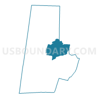
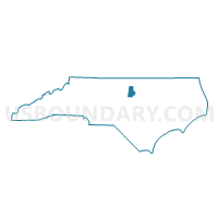
Voting District 29, Durham County, North Carolina
About
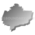
Outline

Summary
| Unique Area Identifier | 639936 |
| Name | Voting District 29 |
| County | Durham County |
| State | North Carolina |
| Area (square miles) | 24.38 |
| Land Area (square miles) | 20.60 |
| Water Area (square miles) | 3.79 |
| % of Land Area | 84.47 |
| % of Water Area | 15.53 |
| Latitude of the Internal Point | 36.05519200 |
| Longtitude of the Internal Point | -78.81192330 |
Maps

Graphs
Select a template below for downloading or customizing gragh for Voting District 29, Durham County, North Carolina


Neighbors
Neighoring Voting District (by Name) Neighboring Voting District on the Map
- Voting District 14-01, Wake County, NC
- Voting District 18, Durham County, NC
- Voting District 19, Durham County, NC
- Voting District 22, Durham County, NC
- Voting District 23, Durham County, NC
- Voting District 28, Durham County, NC
- Voting District 30-2, Durham County, NC
- Voting District 32, Durham County, NC
- Voting District 45, Durham County, NC
- Voting District 52, Durham County, NC
- Voting District BTNR, Granville County, NC
- Voting District CRDM, Granville County, NC
Top 10 Neighboring County Subdivision (by Population) Neighboring County Subdivision on the Map
- Durham township, Durham County, NC (106,210)
- Oak Grove township, Durham County, NC (39,856)
- Lebanon township, Durham County, NC (18,722)
- Dutchville township, Granville County, NC (17,725)
- New Light township, Wake County, NC (7,591)
- Mangum township, Durham County, NC (6,362)
- Carr township, Durham County, NC (3,064)
Top 10 Neighboring Place (by Population) Neighboring Place on the Map
Top 10 Neighboring Unified School District (by Population) Neighboring Unified School District on the Map
- Wake County Schools, NC (900,993)
- Durham Public Schools, NC (267,587)
- Granville County Schools, NC (59,916)
Top 10 Neighboring State Legislative District Lower Chamber (by Population) Neighboring State Legislative District Lower Chamber on the Map
- State House District 40, NC (125,208)
- State House District 31, NC (91,274)
- State House District 32, NC (79,540)
- State House District 55, NC (73,704)
Top 10 Neighboring State Legislative District Upper Chamber (by Population) Neighboring State Legislative District Upper Chamber on the Map
- State Senate District 15, NC (200,862)
- State Senate District 7, NC (186,929)
- State Senate District 20, NC (181,624)
Top 10 Neighboring 111th Congressional District (by Population) Neighboring 111th Congressional District on the Map
Top 10 Neighboring Census Tract (by Population) Neighboring Census Tract on the Map
- Census Tract 539, Wake County, NC (7,605)
- Census Tract 18.01, Durham County, NC (7,123)
- Census Tract 18.02, Durham County, NC (6,736)
- Census Tract 21, Durham County, NC (6,362)
- Census Tract 9706.03, Granville County, NC (6,260)
- Census Tract 17.09, Durham County, NC (6,109)
- Census Tract 16.01, Durham County, NC (5,806)
- Census Tract 18.06, Durham County, NC (5,672)
- Census Tract 9707.03, Granville County, NC (4,067)
- Census Tract 17.08, Durham County, NC (3,989)
Top 10 Neighboring 5-Digit ZIP Code Tabulation Area (by Population) Neighboring 5-Digit ZIP Code Tabulation Area on the Map
- 27703, NC (41,937)
- 27704, NC (34,517)
- 27712, NC (20,035)
- 27522, NC (12,335)
- 27509, NC (10,167)
- 27503, NC (3,471)